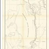
Chart of Swinomish Slough, Skagit Co. Washington : showing proposed channel & dikes (1891)
Title
Chart of Swinomish Slough, Skagit Co. Washington : showing proposed channel & dikes (1891)
Subject
Nautical charts -- Washington (State) -- Swinomish Slough
Description
1 map ; 85 x 45 cm.<br>Bathymetry shown by soundings and isolines<br>Describes an improvement project to make a channel and construct pile dikes<br>"H. Ex. 31 52 1."<br>Indexed in: CIS US serial set index, pt. 14, 2950 (52-1) H.exdoc. 31, map 1 <br>Scale 1:20,000
Creator
United States. Army. Corps of Engineers. Engineer Office<br>Downing, Alfred<br>Savage, John R.
Source
University of Washington Libraries Map Collection
Publisher
Washington : G.P.O.
Date
1892
Contributor
University of Washington Libraries Map Collection
Rights
This image may be freely downloaded and used. Please give credit to the University of Washington Libraries.
Relation
Removed from: Swinomish Slough, Washington : letter from the Acting Secretary of War, transmitting, with a letter from the Chief of Engineers, report of the examination and survey of Swinomish Slough, Washington, with view of constructing a ship channel through same, connecting Saratoga Passage and Skagit Bay with Padilla Bay. Washington, G.P.O., 1892. (Ex. Doc. / 52d Congress, 1st Session, House ; no. 31)
Format
image/jpeg
Language
English
Type
Maps<br>Nautical Charts
Identifier
uwm89<br>Y 1.1/2: Serial 2950 map 3
Coverage
United States -- Washington (State) -- Skagit County -- Swinomish Slough
Collection
Citation
United States. Army. Corps of Engineers. Engineer Office<br>Downing, Alfred<br>Savage, John R., “Chart of Swinomish Slough, Skagit Co. Washington : showing proposed channel & dikes (1891),” Digital Exhibits, accessed November 25, 2024, http://752800.40daj.group/items/show/1835.
