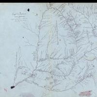
Pays des Porteurs (Country of the Porteurs), (c. 1846)
Title
Pays des Porteurs (Country of the Porteurs), (c. 1846)
Subject
Missions -- Washington (State) -- Maps, Manuscript<br>Missions -- Idaho -- Maps, Manuscript<br>Missions -- Montana-- Maps, Manuscript
Description
1 ms. map: hand col., 26 x 22 cm. <br>In 1840, Jesuit missionary Fr. Pierre Jean DeSmet, traveled to the Pacific Northwest upon request by the Flathead Indian nation. Returning the next year with supplies and a few fellow brethren, DeSmet founded St. Mary's Mission on the St. Joseph River, thirty miles north of present day Missoula, Montana. DeSmet then spent ten (nonconsecutive) years in the northwest region. In those years he baptized thousands of Indians, wrote extensively of his travels, hardships and triumphs, and drew maps of the area. In a letter sent back east, he describes his attempt at map-making: "...I occupied myself occasionally in drawing maps of the countries through which I passed. I availed myself of the best information I could obtain from trappers and intelligent Indians who were well acquainted with the mountain passes and the course of the rivers. Not having had instruments with me, the maps were only an approximation to the true positions." <br>St. Mary's (spelled by DeSmet as "Marie's") is presented in the lower left corner of the map. The closest location for supplies lay at Fort Colville, 320 miles northwest, in eastern Washington. A number of Indians lived near the fort, including those from the Okinakane (Okanogan), Skoyelpi, Chaudiere (Kettle), and Sinpoil nations. St. Paul's, a mission established near Fort Colville, administered to these nations. Further east, DeSmet opened another mission for the Cree Indians, naming it St. Francis Regis. South of this mission lay the Spokane River and the Zingomene (Spokane) people. Further east down the Spokane River lay the Sacred Heart Mission, built for the Pointed Hearts, or Coeur d'Alene Indians.<br> Traveling north, thirty miles from the mouth of the Clark River, DeSmet began to lay the foundation for the Pend d'Oreilles' mission, which he christened St. Ignatius in 1844.<br> North of this location is the Kootenai River and the land of the Kootenai and Arcs-a-plats (Flatbow) Indians. Note the holy cross symbol drawn by DeSmet on the Kootenai River in the center of this map. It was at this site in August 1845 that DeSmet and the Arcs-a-plats tribe erected a cross for the Feast of the Assumption of the Blessed Virgin Mary. Further north along the Kootenai River, DeSmet marked other sites with such crosses--such as the St. Coeur d'Marie and De la Nativitie--where Father DeSmet also held mass. In this area, DeSmet has also located spots where he discovered high levels of gold and other "minerales". DeSmet told no one of these findings, correctly fearing the swarm of settlers that would overtake this land once word of it became known. At the top of this map, to the left of the cross dated "1845" is a small stream DeSmet named "Morigeau". A lone Canadian living with his native family in the wilderness, DeSmet came across Mr. Morigeau while journeying to the Canadian Rockies in search of the Blackfeet nation. All of these occurrences are described in his many letters to friends and family, both in Europe and the eastern United States.
Creator
DeSmet, Pierre Jean, S.J.
Source
Manuscripts, Archives, and Special Collections, WSU Libraries
Date
ca. 1846
Contributor
Manuscripts, Archives, and Special Collections
Rights
Contact Manuscripts, Archives, and Special Collections, for copyright information 509 335-6691
Relation
Is part of Pierre Jean De Smet Papers, 1764-1970 Cage 537<br>http://www.wsulibs.wsu.edu/holland/masc/finders/cg537.htm
Format
image/jpeg
Language
French
Type
Maps
Identifier
WSU 2
Coverage
Washington (State)
Idaho
Montana
Idaho
Montana
Collection
Citation
DeSmet, Pierre Jean, S.J., “Pays des Porteurs (Country of the Porteurs), (c. 1846),” Digital Exhibits, accessed February 21, 2025, http://752800.40daj.group/items/show/1591.
