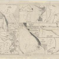
This chart of Puget Sound shewing [sic], the ports of Seattle, Tacoma, Bellingham Bay, Everett, Muckilteo [sic], Blakely Harbour, Port Ludlow, Port Gamble and Eagle Harbour, with the deep water track from the Pacific (1905)
Title
This chart of Puget Sound shewing [sic], the ports of Seattle, Tacoma, Bellingham Bay, Everett, Muckilteo [sic], Blakely Harbour, Port Ludlow, Port Gamble and Eagle Harbour, with the deep water track from the Pacific (1905)
Subject
Nautical charts -- Washington (State) -- Puget Sound<br>Nautical charts -- Washington (State) -- Commencement Bay<br>Nautical charts -- Washington (State) -- Gamble, Port<br>Nautical charts -- Washington (State) -- Bellingham Bay<br>Nautical charts -- Washington (State) -- Townsend, Port<br>Nautical charts -- Washington (State) -- Possession Sound <br>Nautical charts -- Washington (State) -- Eagle Harbor<br>Nautical charts -- Washington (State) -- Elliott Bay<br>Nautical charts -- Washington (State) -- Blakely Harbor<br>Nautical charts -- Washington (State) -- Ludlow, Port<br>Nautical charts -- Juan de Fuca, Strait of (B.C. and Wash.)
Description
10 maps on 1 sheet ; each 29 x 25 cm. or smaller., sheet 54 x 72<br>Depths shown by soundings<br>Contents: Tacoma, Washington -- Port Gamble -- Port Townsend -- Bellingham Bay -- Possession Sound -- Eagle Harbour [Eagle Harbor] -- Cape Flattery to Puget Sound -- City of Seattle -- Blakely Harbour [Blakely Harbor] -- Port Ludlow, Washington<br>"Jun. 1905."<br> Scales differ
Creator
(signature illegible)
Source
University of Washington Libraries Manuscripts, Special Collections, University Archives Division
Publisher
Washington : Washington Stevedore Co.
Date
1905
Contributor
University of Washington Libraries Map Collection
Rights
This image may be downloaded or reproduced for research and educational purposes without prior permission; please give credit to the University of Washington Libraries Manuscripts, Special Collections, University Archives Division. Any commercial use of this material is prohibited without prior permission from the University Libraries. Contact [email protected]
Format
image/jpeg
Language
English
Type
Maps<br>Nautical charts
Identifier
uwm99<br>G4282.P8 P5 1905 .C5
Coverage
United States -- Washington (State) -- Puget Sound
United States -- Washington (State) -- Pierce County -- Commencement Bay
United States -- Washington (State) -- Kitsap County -- Port Gamble
United States -- Washington (State) -- Whatcom County -- Bellingham Bay
United States -- Washington (State) -- Jefferson County -- Port Townsend
United States -- Washington (State) -- Snohomish County -- Possession Sound
United States -- Washington (State) -- Kitsap County -- Eagle Harbor
United States -- Washington (State) -- King County -- Elliott Bay
United States -- Washington (State) -- Kitsap County -- Blakely Harbor
United States -- Washington (State) -- Jefferson County -- Port Ludlow
Northwest Coast of North America -- Strait of Juan de Fuca
Collection
Citation
(signature illegible), “This chart of Puget Sound shewing [sic], the ports of Seattle, Tacoma, Bellingham Bay, Everett, Muckilteo [sic], Blakely Harbour, Port Ludlow, Port Gamble and Eagle Harbour, with the deep water track from the Pacific (1905),” Digital Exhibits, accessed March 13, 2025, http://752800.40daj.group/items/show/1590.
