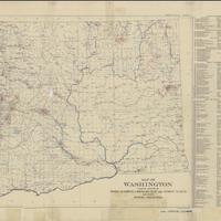
Map of Washington showing location of mines, quarries, limekilns, clay and cement plants and other mineral industries (1918)<br>Mineral resources of Washington, with statistics for 1919 (1918)
Title
Map of Washington showing location of mines, quarries, limekilns, clay and cement plants and other mineral industries (1918)<br>Mineral resources of Washington, with statistics for 1919 (1918)
Subject
Mines and mineral resources -- Washington (State) -- Maps<br>Industries -- Washington (State) -- Location -- Maps
Description
1 map : col. ; 41 x 61 cm<br>Ed. of Aug., 1918<br>Relief shown by spot heights and landforms<br>"A. Hoen & Co. Baltimore, Md."<br>"Bulletin no. 21, plate 1."<br>Includes index to mineral industries<br>Scale ca. 1:1,000,000 (W 125°--W 117°/N 49°--N 45°)
Creator
Washington Geological Survey<br>Landes, Henry, 1867-1936<br>Patty, Ernest N. (Ernest Newton), 1894-
Source
University of Washington Libraries Map Collection
Publisher
Olympia, Wash. : The Survey
Date
1918
Contributor
University of Washington Libraries Map Collection
Rights
This image may be freely downloaded and used. Please give credit to the University of Washington Libraries.
Relation
Separated from: The mineral resources of Washington, with statistics from 1919 / by Ernest N. Patty and Sheldon L. Glover. Olympia, [Wash.] : Frank M. Lamborn Public Printer, 1921. (Bulletin / Washington Geological Survey ; no. 21)
Format
image/jpeg
Language
English
Type
Maps
Identifier
uwm61<br>G4281.H1 1918 .W3
Coverage
Washington (State)
Collection
Citation
Washington Geological Survey<br>Landes, Henry, 1867-1936<br>Patty, Ernest N. (Ernest Newton), 1894-, “Map of Washington showing location of mines, quarries, limekilns, clay and cement plants and other mineral industries (1918)<br>Mineral resources of Washington, with statistics for 1919 (1918),” Digital Exhibits, accessed November 25, 2024, http://752800.40daj.group/items/show/1532.
