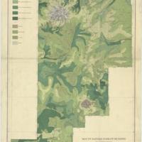
Mount Rainier Forest Reserve, Washington, showing classification of lands (1899)
Title
Mount Rainier Forest Reserve, Washington, showing classification of lands (1899)
Subject
Forests and forestry -- Washington (State) -- Mount Rainier Forest Reserve -- Maps<br>Mount Rainier Forest Reserve (Wash.) -- Maps
Description
1 map : col. ; 60 x 40 cm<br>Relief shown by contours and spot heights<br>Contour interval 500 feet<br>Shows ten classes of timber density and land cover<br>Plate XXXIII from the "Twenty-first annual report" of the U.S. Geological Survey, Part 5, Forest reserves (1900)<br>"Julius Bien & Co. Lith. N.Y."<br> Scale ca. 1:250,000 (W 122°15--W 121°00/N 47°10--N 45°45)
Creator
Plummer, Fred G. (Fred Gordon), 1864-1913<br>Geological Survey (U.S.)<br>Geological Survey (U.S.) Annual report
Source
University of Washington Libraries Manuscripts, Special Collections, University Archives Division
Publisher
Washington, D.C. : U.S. Geological Survey
Date
1899
Contributor
University of Washington Libraries Map Collection
Rights
This image may be downloaded or reproduced for research and educational purposes without prior permission; please give credit to the University of Washington Libraries Manuscripts, Special Collections, University Archives Division. Any commercial use of this material is prohibited without prior permission from the University Libraries. Contact [email protected]
Format
image/jpeg
Language
English
Type
Maps
Identifier
uwm54<br>G4282.M595 K1 1899 .P5
Coverage
Washington (State) -- Mount Rainier Forest Reserve
Collection
Citation
Plummer, Fred G. (Fred Gordon), 1864-1913<br>Geological Survey (U.S.)<br>Geological Survey (U.S.) Annual report, “Mount Rainier Forest Reserve, Washington, showing classification of lands (1899),” Digital Exhibits, accessed November 25, 2024, http://752800.40daj.group/items/show/1531.
