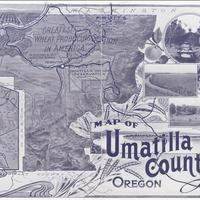
Map of Umatilla County Oregon (1908)
Title
Map of Umatilla County Oregon (1908)
Subject
Umatilla County (Or.) -- Description and travel -- Maps <br> Irrigation farming -- Umatilla County (Or.) -- Maps <br> Land use -- Oregon -- Maps
Description
1 map; 20 x 27 cm. <br>Insets: Railroad Map of Oregon and California; Four scenic views. <br>Umatilla Indian Reservation identified in center of map.
Creator
Sunset Magazine Homeseekers' Bureau.
Source
Manuscripts, Archives, and Special Collections, WSU Libraries
Publisher
Pendleton, OR : Umatilla County Publicity Committee
Date
1908
Contributor
Manuscripts, Archives, and Special Collections
Rights
Contact Manuscripts, Archives, and Special Collections, for copyright information 509 335-6691
Relation
Is part of Umatilla County, Oregon : irrigated lands, small farms and fruits.
Format
image/jpeg
Language
English
Type
Maps
Identifier
wsu 602 <br> F882.U4 S835 1908
Coverage
United States -- Oregon -- Umatilla County
Collection
Citation
Sunset Magazine Homeseekers' Bureau., “Map of Umatilla County Oregon (1908),” Digital Exhibits, accessed February 22, 2025, http://752800.40daj.group/items/show/2260.
