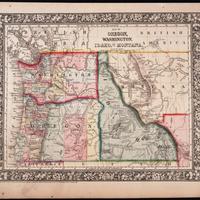
Map of Oregon, Washington, Idaho and part of Montana. (1860)
Title
Map of Oregon, Washington, Idaho and part of Montana. (1860)
Subject
Washington Territory -- Maps<br> Washington (State) -- Boundaries<br> Oregon -- Maps<br> Idaho -- Maps<br> Idaho Territory -- Maps<br> Montana -- Maps
Description
1 map : hand col. ; 27 x 34 cm.<br> Relief shown by hachures.<br> Shows counties, cities, railroads, routes of wagon trails, and rivers.<br> Scale ca. 1:4,435,000<br> Lower right: 50.<br> Decorative border.<br> Dated 1860 in bottom margin, but some question whether that might be the date of the original copyright of the base map.
Creator
Mitchell, S. Augustus (Samuel Augustus), Jr.
Source
Tacoma Public Library Northwest Room
Publisher
Philadelphia : S. A. Mitchell, Jr.
Date
1860
Contributor
Tacoma Public Library Northwest Room
Rights
This image may be downloaded or reproduced for research and educational purposes without prior permission; please give credit to the Tacoma Public Library Northwest Room and the Early Washington Maps digital collection. Any commercial use of this material is prohibited without prior permission from the Tacoma Public Library Northwest Room. Contact: [email protected]
Relation
Is part of Mitchell's new general atlas, 1860
Format
image/jpeg
Language
English
Type
Maps
Identifier
tpl ore60
Coverage
United States -- Washington (Terr.)
United States -- Oregon
United States -- Idaho
United States -- Montana
United States -- Oregon
United States -- Idaho
United States -- Montana
Collection
Citation
Mitchell, S. Augustus (Samuel Augustus), Jr., “Map of Oregon, Washington, Idaho and part of Montana. (1860),” Digital Exhibits, accessed February 21, 2025, http://752800.40daj.group/items/show/2258.
