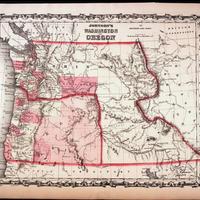
Johnson's Washington and Oregon. (1863)
Title
Johnson's Washington and Oregon. (1863)
Subject
Washington Territory -- Maps<br> Washington (State) -- Boundaries<br> Oregon -- Maps<br> Idaho -- Maps<br> Idaho Territory -- Maps<br> Montana -- Maps
Description
1 map : hand col. ; 32 x 40 cm.<br> Relief shown by hachures.<br> Shows counties, cities, locations of native American tribal groups, and proposed railroad.<br> Scale ca. 1:3,500,000<br> On verso: portion of "Historical and Statistical View of the United States, 1860", tables for Vermont, Virginia and Washington.<br> In lower right margin: 57.<br> Decorative border.<br> Oregon counties Jackson and Josephine have been interchanged.
Creator
Johnson and Ward.<br> Johnson, A. J. (Alvin Jewett), 1827-1884.
Source
Tacoma Public Library Northwest Room
Publisher
New York : Johnson and Ward
Date
1863
Contributor
Tacoma Public Library Northwest Room
Rights
This image may be downloaded or reproduced for research and educational purposes without prior permission; please give credit to the Tacoma Public Library Northwest Room and the Early Washington Maps digital collection. Any commercial use of this material is prohibited without prior permission from the Tacoma Public Library Northwest Room. Contact: [email protected]
Relation
Is part of Johnson's New illustrated family atlas of the world
Format
image/jpeg
Language
English
Type
Maps
Identifier
tpl johns63
Coverage
United States -- Washington (Terr.)
United States -- Oregon
United States -- Idaho
United States -- Oregon
United States -- Idaho
Collection
Citation
Johnson and Ward.<br> Johnson, A. J. (Alvin Jewett), 1827-1884., “Johnson's Washington and Oregon. (1863),” Digital Exhibits, accessed February 21, 2025, http://752800.40daj.group/items/show/2255.
