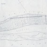
Columbia River Vancouver Wash. to Mouth of Willamette River (1859)
Title
Columbia River Vancouver Wash. to Mouth of Willamette River (1859)
Subject
Columbia River -- Maps. <br> Vancouver (Wash.) -- History.
Description
1 map: 29 x 69 cm. <br> Scale: 4.25 inches = 1 mile. <br>Soundings are expressed in feet and show the depths at low water. Proposed extension of existing dam shown by dashed line. Proposed dredging to 20 ft at low water shown by hachures. <br> In order to make the city of Vancouver, Washington, more accessible by water up the Columbia, a proposal was adopted in 1892 to dam half the river south of Hayden Island, thus forcing water north of the island and creating a deeper channel past Vancouver. Work commenced that year and continued until April 1893, at which point the river rose and submerged both the dam and the island with only 60 feet remaining to be constructed. When the water receded, the island had been eroded such that 470 feet of dam was now needed. By the time a revetment was constructed to prevent further erosion, a total of 700 more feet of dam was required. Unfortunately, this was well beyond the original budget of the project. This map comes from a letter from the Secretary of War to the 54th Congress, effectively requesting more money so that the project could be finished.
Creator
Warrick, Robert
Source
Manuscripts, Archives, and Special Collections, WSU Libraries
Publisher
Washington, D.C. : [s.n.]
Date
1895
Contributor
Manuscripts, Archives, and Special Collections
Rights
Contact Manuscripts, Archives, and Special Collections, for copyright information 509 335-6691
Relation
Is found in Letter from the Secretary of War, in response to resolution of the United States Senate dated December 24, 1895, directing that the Secretary of War "send to the Senate any information in his possession with reference to the continued improvement of the Columbia River between the mouth of the Willamette River and the city of Vancouver."
Format
image/jpeg
Language
English
Type
Maps
Identifier
wsu 575 <br> F853 . U55 1895
Coverage
United States -- Oregon -- Columbia River
United States -- Washington (State) -- Columbia River
United States -- Washington (State) -- Columbia River
Collection
Citation
Warrick, Robert, “Columbia River Vancouver Wash. to Mouth of Willamette River (1859),” Digital Exhibits, accessed February 22, 2025, http://752800.40daj.group/items/show/2084.
