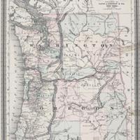
Johnson's Oregon and Washington. (1865)
Title
Johnson's Oregon and Washington. (1865)
Subject
Washington (Terr.) -- Maps<br>Oregon -- Maps
Description
1 map: hand col., 29 x 43 cm.<br>Scale: 1.5 inches = 40 miles.<br>Longitude west from Greenwich at top. Longitude west from Washington at bottom.<br>"Entered according to Act of Congress in the year 1865 by A.J. Johnson in the Clerks Office of the District Court of the United States for the Southern District of New York"<br>"Historic and Statistical View of the United States" on recto.
Creator
Johnson, Alvin J.
Source
Manuscripts, Archives, and Special Collections, WSU Libraries
Publisher
New York: Alvin J. Johnson & co.
Date
1865
Contributor
Manuscripts, Archives, and Special Collections
Rights
Contact Manuscripts, Archives, and Special Collections, for copyright information 509 335-6691
Format
image/jpeg
Language
English
Type
Maps
Identifier
wsu 306
Coverage
United States -- Washington (Terr.)
Oregon
Oregon
Collection
Citation
Johnson, Alvin J., “Johnson's Oregon and Washington. (1865),” Digital Exhibits, accessed February 21, 2025, http://752800.40daj.group/items/show/2063.
