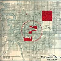
City of Spokane Falls, Washington. (1890)
Title
City of Spokane Falls, Washington. (1890)
Subject
Washington (State) --Spokane -- Description and travel -- Maps
Description
1 map: col., 28 x 27 cm.<br>Steam railroads shown by heavy black lines. Horse car lines, electric motor lines, and cable car lines all shown by dashed lines.<BR>"Property indicated in red is controlled exclusively by L.C. Dillman & Co."<br>Red circle indicates radius of one mile from business center.<br>Scale: 4 inches = 7 miles<br>In October of 1890, Spokane hosted the Northwest Industrial Exposition, just 14 months after the vast majority of the Spokane business district had burned to the ground in a major fire. As the name implies, this was primarily a northwestern exposition, drawing industrial exhibitors from mostly the neighboring states but also from as far away as Minnesota. This map is a real estate advertisement located within a hardbound promotional brochure from the exposition.
Creator
Northwestern Industrial Exposition (1890 : Spokane Falls, Wash.)
Source
Manuscripts, Archives, and Special Collections, WSU Libraries
Publisher
Buffalo, NY : Matthews, Northrup & Co.
Date
1890
Contributor
Manuscripts, Archives, and Special Collections
Rights
Contact Manuscripts, Archives, and Special Collections, for copyright information 509 335-6691
Relation
Is found in The city of Spokane Falls and its tributary resources / issued by the Northwestern Industrial Exposition, Spokane Falls, Washington, October 1st to November 1st, 1890. <br>F899.S7 N67 1890 c.3
Format
image/jpeg
Language
English
Type
Maps
Identifier
wsu 522<br>F899.S7 N67 1890 c.3
Coverage
United States--Washington (State) -- Spokane
Collection
Citation
Northwestern Industrial Exposition (1890 : Spokane Falls, Wash.), “City of Spokane Falls, Washington. (1890),” Digital Exhibits, accessed November 25, 2024, http://752800.40daj.group/items/show/2012.
