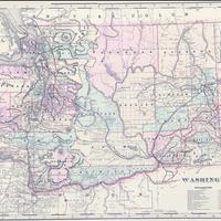
Washington. (1891)
Title
Washington. (1891)
Subject
Railroads -- Washington (State) -- Maps.
Description
1 map : col. ; 39 x 54 cm., on sheet 45 x 65 cm. <br>Relief shown by hachures and spot heights. <br>Shows railroads coded by color. <br>From: Walker's international railroad atlas. <br>Prime meridians: Greenwich and Washington. <br>Atlas p. numbers in upper margin: 264-265. <br>"Index of maps" in margins. <br>Partial indexes of Washington and Oregon on verso. <br>002-116880394
Creator
Walker, Henry B.
Source
Manuscripts, Archives, and Special Collections, WSU Libraries
Publisher
[Chicago, Ill.? : H.B. Walker, 1891]
Date
1891
Contributor
Manuscripts, Archives, and Special Collections
Rights
Contact Manuscripts, Archives, and Special Collections, for copyright information 509 335-6691
Format
image/jpeg
Language
English
Type
Maps
Identifier
wsu 354<br>G4281.P3 1891 .W35x
Coverage
United States--Washington (State)
Collection
Citation
Walker, Henry B., “Washington. (1891),” Digital Exhibits, accessed February 22, 2025, http://752800.40daj.group/items/show/2001.
