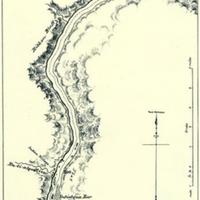
Map of the Upper Columbia River, from the international boundary line to Snake River, on a scale of one inch to two miles. (1882) Sheet 15. [Entiat River]
Title
Map of the Upper Columbia River, from the international boundary line to Snake River, on a scale of one inch to two miles. (1882) Sheet 15. [Entiat River]
Subject
Columbia River Valley -- Maps
Description
1 map : 19 x 13 cm.<br>"Sen. Ex. Doc. No. 186, 1st sess., 47th Cong."<br>Scale approximately 2 miles to 1 inch. <br>A larger scale version of this map can be seen at: http://kaga.wsulibs.wsu.edu/zoom/zoom.php?map=wsu480 <br>The next section of the map moving upstream is at: http://kaga.wsulibs.wsu.edu/zoom/zoom.php?map=wsu494 <br>The next section of the map moving downstream is at: http://kaga.wsulibs.wsu.edu/zoom/zoom.php?map=wsu496
Creator
United States. Army. Corps of Engineers.
Source
Manuscripts, Archives, and Special Collections, WSU Libraries
Publisher
Washington, D.C., Govt. print. off.
Date
1882
Contributor
Manuscripts, Archives, and Special Collections
Rights
Contact Manuscripts, Archives, and Special Collections, for copyright information 509 335-6691
Relation
Is part of Report of an examination of the Upper Columbia River and the territory in its vicinity in September and October, 1881, to determine its navigability and adaptability to steamboat transportation.
Format
image/jpeg
Language
English
Type
Maps
Identifier
wsu495<br>F853 .U58
Coverage
Washington (Terr.) -- Columbia River
Collection
Citation
United States. Army. Corps of Engineers., “Map of the Upper Columbia River, from the international boundary line to Snake River, on a scale of one inch to two miles. (1882) Sheet 15. [Entiat River],” Digital Exhibits, accessed November 27, 2024, http://752800.40daj.group/items/show/1980.
