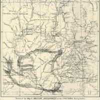
Portion of the Map of Military Department of the Columbia showing location of River Survey Sheets. (1882)
Title
Portion of the Map of Military Department of the Columbia showing location of River Survey Sheets. (1882)
Subject
Columbia River Valley -- Maps
Description
1 map : 33 x 33 cm.<br>"Sen. Ex. Doc. No. 186, 1st sess., 47th Cong."<br>Scale approximately 18 miles to 1 inch. <br>In September and October of 1881, under orders from Brig. Gen. Nelson A. Miles, Thomas W. Symons traveled and closely mapped the entirety of the Columbia River from the Canadian border to the point where the Snake and Columbia Rivers met. His stated goal was "to determine its navigability and the advisability of putting steamboats on it to be used in the transportation of troops, stores, supplies, &c." This map consisted of this index page, the 25 more detailed maps indicated on the index, and a few smaller close-up maps of the more obstructed parts of the river. Symon's report also included historical and geological notes on the Columbia and its basin, as well as notes on improving the navigability of the River.
Creator
United States. Army. Corps of Engineers.
Source
Manuscripts, Archives, and Special Collections, WSU Libraries
Publisher
Washington, D.C., Govt. print. off.
Date
1882
Contributor
Manuscripts, Archives, and Special Collections
Rights
Contact Manuscripts, Archives, and Special Collections, for copyright information 509 335-6691
Relation
Is part of Report of an examination of the Upper Columbia River and the territory in its vicinity in September and October, 1881, to determine its navigability and adaptability to steamboat transportation.
Format
image/jpeg
Language
English
Type
Maps
Identifier
wsu 480<br>F853 .U58
Coverage
Washington (Terr.) -- Columbia River
Collection
Citation
United States. Army. Corps of Engineers., “Portion of the Map of Military Department of the Columbia showing location of River Survey Sheets. (1882),” Digital Exhibits, accessed November 26, 2024, http://752800.40daj.group/items/show/1973.
