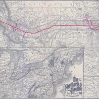
Map of the Northern Pacific Railroad and Connections, (1886)
Title
Map of the Northern Pacific Railroad and Connections, (1886)
Subject
Northwestern States -- Maps.<br> Northern Pacific Railroad Company.<br>Railroads -- U.S. -- Maps
Description
1 map : col., 38 x 77 cm. <br>In 1888, the Northern Pacific finally completed the last requirement of its original charter, the construction of a direct route to the Puget Sound. Stampede Pass across the Cascades opened in May of 1888.
Creator
Winser, Henry Jacob, 1823-1896.
Source
Manuscripts, Archives, and Special Collections, WSU Libraries
Publisher
St. Paul : Northern News Co., 1888, c1886.
Date
1888
Contributor
Manuscripts, Archives, and Special Collections
Rights
Contact Manuscripts, Archives, and Special Collections, for copyright information 509 335-6691
Relation
Is part of The great Northwest : a guide-book and itinerary for the use of tourists and travelers over the lines of the Northern Pacific Railroad, the Oregon Railway and Navigation Company, and the Oregon and California Railroad ... with maps and many illustrations.
Format
image/jpeg
Language
English
Type
Maps
Identifier
wsu 465<br>F 597 W77 1888
Coverage
United States -- West
Collection
Citation
Winser, Henry Jacob, 1823-1896., “Map of the Northern Pacific Railroad and Connections, (1886),” Digital Exhibits, accessed February 22, 2025, http://752800.40daj.group/items/show/1954.
