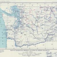
Map of Washington showing location of mining districts U.S. Geological Survey, Otis Smith, director, (1912)
Title
Map of Washington showing location of mining districts U.S. Geological Survey, Otis Smith, director, (1912)
Subject
Mines and mineral resources -- Washington (State) -- Maps.
Description
1 map : col. ; 19 x 27 cm. <br>Series Bulletin ; 507. <br> Geological Survey bulletin ; 507. <br>Shows predominant mineral for each mining district. <br> "Plate 15"--Map has been cut from larger sheet. Mounted on cloth backing. <br>George Otis Smith, later director of the U.S. Geological Survey, actually has a hand in surveying the geography of Washington State. In the early 1900s, Smith was part of a team of surveyors sent to study the American-Canadian border when the two neighbors agreed to have the border resurveyed. <br>For most of the 1800s, maps had focused on land in terms of acquiring access (railroads, trails), and assuring settlement. With the interest engendered by the Californian and Alaskan gold rushes of the latter half of that century, maps began to focus on the geologic aspects of the northwest as well.
Creator
Geological Survey (U.S.)
Source
Manuscripts, Archives, and Special Collections, WSU Libraries
Publisher
[Washington, D.C.?] : U.S. Geological Survey, 1912.
Date
1912
Contributor
Manuscripts, Archives, and Special Collections
Rights
Contact Manuscripts, Archives, and Special Collections, for copyright information 509 335-6691
Format
image/jpeg
Language
English
Type
Maps
Identifier
WSU 334 <br> G4281.H1 1912 .G4x
Coverage
United States--Washington (State)
Collection
Citation
Geological Survey (U.S.), “Map of Washington showing location of mining districts U.S. Geological Survey, Otis Smith, director, (1912),” Digital Exhibits, accessed February 20, 2025, http://752800.40daj.group/items/show/1904.
