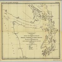
Chart showing the location and character of the principal fisheries and fishing grounds of the state of Washington from Gray's Harbor to Olympia, including Puget Sound : season of 1889 (1889)
Title
Chart showing the location and character of the principal fisheries and fishing grounds of the state of Washington from Gray's Harbor to Olympia, including Puget Sound : season of 1889 (1889)
Subject
Fisheries -- Washington (State) -- Maps
Description
1 map ; 40 x 42 cm.<br>Letters and symbols indicate fishing grounds for salmon, trout, halibut, smelt, rockfish and oysters. Also shows gill-nets, pound nets and canneries. Includes coastal features, islands and cities. Shows the Pacific coast of northern Washington, Strait of Juan de Fuca, Puget Sound and Washington Sound<br>"Report U.S.F.C. 1888--(To face page 243.) Pacific coast fisheries."<br>"Plate XLIII."<br>Indexed in: CIS US serial set index, pt. 14, 2806 (51-1), H.misdoc. 274, map 15<br>Scale ca. 1:600,000
Creator
United States Fish Commission
Source
University of Washington Libraries Government Publications Section
Publisher
Washington : G.P.O.
Date
1891
Contributor
University of Washington Libraries Map Collection
Rights
This image may be freely downloaded and used. Please give credit to the University of Washington Libraries.
Relation
Removed from: Report of the Commissioner for 1888 / U.S. Commission of Fish and Fisheries
Format
image/jpeg
Language
English
Type
Maps
Identifier
uwm139<br>Y 1.1/2: Serial 2806 map 3
Coverage
United States -- Washington (State)
Collection
Citation
United States Fish Commission, “Chart showing the location and character of the principal fisheries and fishing grounds of the state of Washington from Gray's Harbor to Olympia, including Puget Sound : season of 1889 (1889),” Digital Exhibits, accessed March 12, 2025, http://752800.40daj.group/items/show/1782.
