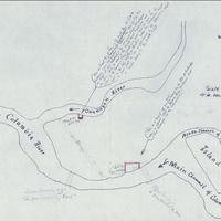
Map of tract of land in the State of Washington where the Hudson Bay Company built Fort Okanogan on the Columbia, 1838
Title
Map of tract of land in the State of Washington where the Hudson Bay Company built Fort Okanogan on the Columbia, 1838
Subject
Columbia River -- Maps, Manuscript<br>Okanogan River Maps, Manuscript<br>Fort Okanogan
Description
1 ms. map ; 40 x 49 cm. <br>This is a manuscript map probably drawn by Judge Brown describing two tracts of land where the original Fort Okanogan and "Fort Okanogan on the Columbia" stood.
Creator
Brown, William Compton
Source
Manuscripts, Archives, and Special Collections, WSU Libraries
Contributor
Manuscripts, Archives, and Special Collections
Rights
Contact Manuscripts, Archives, and Special Collections, for copyright information 509 335-6691
Relation
Is Part of William Compton Brown Papers, 1830-1963, Cage 196: http://www.wsulibs.wsu.edu/holland/masc/finders/cg196.htm
Format
image/jpeg
Language
English
Type
Maps
Identifier
WSU 215
Coverage
United States--Washington (State)--Okanogan County
Collection
Citation
Brown, William Compton, “Map of tract of land in the State of Washington where the Hudson Bay Company built Fort Okanogan on the Columbia, 1838,” Digital Exhibits, accessed November 25, 2024, http://752800.40daj.group/items/show/1755.
