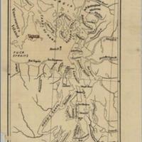
Pacific northwest waters between Fort Nesqually and Ft. Langley (1841)
Title
Pacific northwest waters between Fort Nesqually and Ft. Langley (1841)
Subject
Northwest, Pacific -- Maps
Description
1 map ; 23 x 12 cm.<br>Base map identifying islands, bays, inlets and canals in the Pacific Northwest. Includes Rosario Strait and Canal de Haro involved in the boundary dispute between Great Britain and the United States. Also shows towns, including Victoria<br>Map depicts the forts of the Hudson Bay Company in the 1840s, but includes features from 1872 as points of reference.<br>Indexed in: CIS US serial set index, pt. 14, 1557 (42-3) H.exdoc. 1, map 8<br>Scale 1:760,320. 12 miles = 1 in.
Source
University of Washington Libraries Government Publications Section
Publisher
Washington : G.P.O.
Date
1873
Contributor
University of Washington Libraries Map Collection
Rights
This image may be freely downloaded and used. Please give credit to the University of Washington Libraries.
Relation
Removed from: Papers relating to the foreign relations of the United States, transmitted to Congress with the annual message of the President, December 2, 1872, part II. Washington : G.P.O., 1872. (Ex. Doc. / 42d Congress, 2d Session, House ; no. 1, pt. 1)
Format
image/jpeg
Language
English
Type
Maps
Identifier
uwm163<br>Y 1.1/2: Serial 1557 map N
Coverage
Northwest Coast of North America -- Haro Strait
Washington (State) -- Puget Sound
Washington (State) -- Rosario Strait
Washington (State) -- Puget Sound
Washington (State) -- Rosario Strait
Collection
Citation
“Pacific northwest waters between Fort Nesqually and Ft. Langley (1841),” Digital Exhibits, accessed November 26, 2024, http://752800.40daj.group/items/show/1736.
