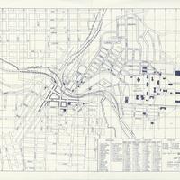
Map of Pullman and the State College of Washington, (1928)
Title
Map of Pullman and the State College of Washington, (1928)
Subject
Washington State University--Maps<br>Pullman (Wash.)--Maps<br>Washington State College<br>Washington Agriculture School
Description
1 map; 26 x 34 cm. Scale 1/8"=100'<br>Map includes building, street, and church directories. Business district and paved streets are indicated.<br>This map was prepared by the Highway Engineering Department of Washington State College (WSU).<br>Opening its doors to students in 1892 as a land-grant school, the Washington Agricultural College had about five buildings and three major fields of study: agriculture, mechanic arts, and domestic science. The school grew within the decade however, and new departments were formed. The school changed its name in 1905 to Washington State College in part to reflect these additions. While times were lean during World War I and directly after, by 1928 the nation experienced a surge in its economy. Washington State College was no different. A number of buildings were completed during this time, including White Hall and Troy Hall, the Hospital and the field house. Within the decade of the 1920s also came the additions of the Student's Book Store and the Radio Station--KWSC.
Creator
Washington State University Highway Engineering Department
Source
Manuscripts, Archives, and Special Collections, WSU Libraries
Publisher
Pullman (Wash.) : Washington State University
Date
1928
Contributor
Manuscripts, Archives, and Special Collections
Rights
Contact Manuscripts, Archives, and Special Collections, for copyright information 509 335-6691
Format
image/jpeg
Language
English
Type
Maps
Identifier
WSU 112
Coverage
United States--Washington (State)--Whitman County--Washington State University
Collection
Citation
Washington State University Highway Engineering Department, “Map of Pullman and the State College of Washington, (1928),” Digital Exhibits, accessed November 25, 2024, http://752800.40daj.group/items/show/1657.
