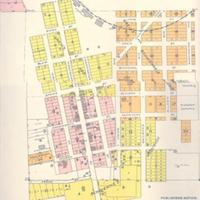
Plat map of Union Town, (1910)<br>Plat book of Whitman County, Washington compiled and published from actual surveys and the County records by Anderson Map Company
Title
Plat map of Union Town, (1910)<br>Plat book of Whitman County, Washington compiled and published from actual surveys and the County records by Anderson Map Company
Subject
Union Town (Wash.)--Maps<br>Whitman County (Wash.) -- Maps<br>
Description
1 map: col., 40 x 32 cm. <br>Plat map from the Whitman County city of Farmington.<br>Scale 400'=1"<br>Located between Union Flat, the earliest settlement founded in Whitman County (1869), and Cow Creek (1879), Union Town was named by Jesuit missionary Fr. Joseph Cataldo for its connection between the two. The Post Office was established in 1878 and the town incorporated in 1888. Due to technicalities in the filing of the report, the town was officially incorporated in 1890.
Creator
Anderson Map Company.
Source
Manuscripts, Archives, and Special Collections, WSU Libraries
Publisher
Seattle, Wash. : Anderson Map Company
Date
1910
Contributor
Manuscripts, Archives, and Special Collections
Rights
Contact Manuscripts, Archives, and Special Collections, for copyright information 509 335-6691
Relation
Is part of Plat Book of Whitman County Washington Compiled and Published from actual Surveys and the County Records by Anderson Map Company Seattle, Wash 1910
Format
image/jpeg
Language
English
Type
Maps<br>Plats
Identifier
WSU 107
Coverage
United States--Washington (State)--Whitman County--Union Town
Collection
Citation
Anderson Map Company., “Plat map of Union Town, (1910)<br>Plat book of Whitman County, Washington compiled and published from actual surveys and the County records by Anderson Map Company,” Digital Exhibits, accessed March 13, 2025, http://752800.40daj.group/items/show/1651.
