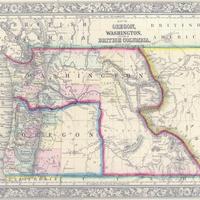
Map of Oregon, Washington, and British Columbia, (1860).
Title
Map of Oregon, Washington, and British Columbia, (1860).
Subject
Oregon--Maps<br>Washington (State)--Maps<br>Washington Territory<br>British Columbia--Maps
Description
1 map: col., 37 x 30 cm. <br>This map dates between March 2nd, 1861 (when the Dakota Territory was formed) and March 4th, 1863 (when the Idaho Territory was formed from eastern Washington and western Dakota) <br>Nearing retirement from a thirty year long and rather successful career, S. Augustus Mitchell printed this map showcasing Oregon, the Territory of Washington, and British Columbia. Washington became a territory in 1853, arguing that distances to Willamette Valley kept them from obtaining a voice in the Oregon territorial government. As this map shows, when it split from Oregon proper the Washington territory included parts of Wyoming and Montana and all of Idaho. Territorial government for Idaho would not be approved until 1863. When Mitchell retired he left the business for his son to manage.
Creator
Mitchell, S. Augustus (Samuel Augustus), 1792-1868.
Source
Manuscripts, Archives, and Special Collections, WSU Libraries
Publisher
[Philadelphia: Mitchell, S. Augustus, 1860]
Date
1860
Contributor
Manuscripts, Archives, and Special Collections
Rights
Contact Manuscripts, Archives, and Special Collections, for copyright information 509 335-6691
Format
image/jpeg
Language
English
Type
Maps
Identifier
WSU 7
Coverage
Oregon
Washington (State)
Washington Territory
Dakotah Territory
British Columbia
Washington (State)
Washington Territory
Dakotah Territory
British Columbia
Collection
Citation
Mitchell, S. Augustus (Samuel Augustus), 1792-1868., “Map of Oregon, Washington, and British Columbia, (1860).,” Digital Exhibits, accessed November 25, 2024, http://752800.40daj.group/items/show/1642.
