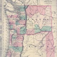
Map of Oregon and Washington, (1865)
Title
Map of Oregon and Washington, (1865)
Subject
Oregon--Maps<br>Washington (State)--Maps<br>Washington Territory<br>Colton, J.H.<br>Johnson, A.J.
Description
1 map: col., 34 x 45 cm.<br>This map, published by A.J. Johnson and his partner, Ward, shows the State of Oregon (entered into the Union in 1859), and Washington Territory. By 1865 the eastern border of Washington Territory had been defined, with Idaho's western border set after its official territorial status came in 1863. While Johnson is well known for purchasing the steel plates and copyrights of renowned mapmaker, J.H.Colton, some sources place 1865 as the date when Johnson stopped using the Colton templates and had begun to create his own lithographs.
Creator
Johnson, A. J. (Alvin Jewett), 1827-1884
Source
Manuscripts, Archives, and Special Collections, WSU Libraries
Publisher
New York: A. J. Johnson, 1865<br>Johnson & Ward
Date
1865
Contributor
Manuscripts, Archives, and Special Collections
Rights
Contact Manuscripts, Archives, and Special Collections, for copyright information 509 335-6691
Format
image/jpeg
Language
English
Type
Maps
Identifier
WSU 19
Coverage
Oregon
Washington (State)
Washington (State)
Collection
Citation
Johnson, A. J. (Alvin Jewett), 1827-1884, “Map of Oregon and Washington, (1865),” Digital Exhibits, accessed November 25, 2024, http://752800.40daj.group/items/show/1639.
