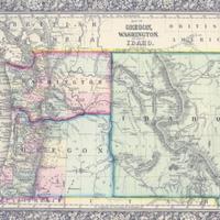
Map of Oregon, Washington and Idaho, (1860)
Title
Map of Oregon, Washington and Idaho, (1860)
Subject
Oregon--Maps<br>Washington (State)--Maps<br>Washington Territory<br>Idaho--Maps
Description
1 map: col., 38 x 30 cm. <br>This map dates from between March 4th, 1864 (when the Idaho Territory was formed) and May 26th, 1864 (when the Montana Territory was formed out of eastern Idaho). <br>Though dated 1860 at the bottom, that was the date of original copyright of the base map. Territory/state borders were redrawn, and territory names corrected onto an older map to produce this map. You can compare this one to a version from approximately two years prior which is located here: http://kaga.wsulibs.wsu.edu/zoom/zoom.php?map=wsu7
Creator
Mitchell, S. Augustus (Samuel Augustus), 1792-1868.
Source
Manuscripts, Archives, and Special Collections, WSU Libraries
Date
1860
Contributor
Manuscripts, Archives, and Special Collections
Rights
Contact Manuscripts, Archives, and Special Collections, for copyright information 509 335-6691
Format
image/jpeg
Language
English
Type
Maps
Identifier
WSU 17
Coverage
Oregon
Washington (State)
Idaho
Washington (State)
Idaho
Collection
Citation
Mitchell, S. Augustus (Samuel Augustus), 1792-1868., “Map of Oregon, Washington and Idaho, (1860),” Digital Exhibits, accessed February 21, 2025, http://752800.40daj.group/items/show/1630.
