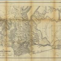
Map of a part of Washington Territory : to accompany the report of the Surveyor General (1861)
Title
Map of a part of Washington Territory : to accompany the report of the Surveyor General (1861)
Subject
Washington (State) -- Surveys -- Maps<br>Surveys -- Washington Territory
Description
1 map ; 56 x 71 cm.<br>Relief shown by hachures<br>"Sen.Ex.Doc. No.1. 37th Cong. 2nd Sess."<br>Shows progress of the township surveys in western Washington Territory. Indicates surveys executed, under contract, and proposed. Includes Indian reservations, prairies, trail and roads, and land claims of the Puget Sound Agricultural Company. Shows topography, hydrography, and forts<br>"Sheet no. 2"<br>Indexed in: CIS US serial set index, pt. 14, 1120 (37-2) S.exdoc. 1, map 4<br>Scale not given
Creator
United States. Surveyor General<br>Tilton, James
Source
University of Washington Libraries Government Publications Section
Publisher
Washington : G.P.O.
Date
1861
Contributor
University of Washington Libraries Map Collection
Rights
This image may be freely downloaded and used. Please give credit to the University of Washington Libraries.
Relation
Removed from: Message of the President of the United States to the two houses of Congress at the commencement of the second session of the thirty-seventh Congress. Washington : G.P.O., 1861. (Ex. Doc. / 37th Congress, 2d Session, Senate ; no. 1)
Format
image/jpeg
Language
English
Type
Maps
Identifier
uwm98<br>Y 1.1/2: Serial 1120 map 1
Coverage
Washington (State)
Collection
Citation
United States. Surveyor General<br>Tilton, James, “Map of a part of Washington Territory : to accompany the report of the Surveyor General (1861),” Digital Exhibits, accessed February 21, 2025, http://752800.40daj.group/items/show/1628.
