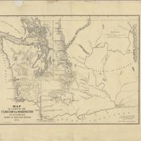
Map of a part of the Territory of Washington : to accompany report of Surveyor General (1855)
Title
Map of a part of the Territory of Washington : to accompany report of Surveyor General (1855)
Subject
Washington (State) -- Maps<br>Surveys -- Washington Territory
Description
1 map : mounted on cloth backing ; 37 x 49 cm.<br>Relief shown by hachures<br>"September 20th, 1855."<br>Scale 1:1,140,480. 18 miles to 1 in. (W 125°--W 117°/N 49°--N 46°)
Creator
Tilton, James<br>Washington (State). Surveyor General's Office<br>A. Hoen & Co.
Source
University of Washington Libraries Manuscripts, Special Collections, University Archives Division<br>Manuscripts, Archives, and Special Collections, WSU Libraries
Publisher
Olympia, Washington Territory : Surveyor Generals Office, (Baltimore : Lith. by A. Hoen & Co.)
Date
1855
Contributor
University of Washington Libraries Map Collection
Rights
This image may be downloaded or reproduced for research and educational purposes without prior permission; please give credit to the University of Washington Libraries Manuscripts, Special Collections, University Archives Division. Any commercial use of this material is prohibited without prior permission from the University Libraries. Contact [email protected]
Format
image/jpeg
Language
English
Type
Maps
Identifier
uwm110<br>G4280 1855 .T5<br>wsu 314
Coverage
United States -- Washington (State)
Collection
Citation
Tilton, James<br>Washington (State). Surveyor General's Office<br>A. Hoen & Co., “Map of a part of the Territory of Washington : to accompany report of Surveyor General (1855),” Digital Exhibits, accessed November 25, 2024, http://752800.40daj.group/items/show/1526.
